Rolling in Wyoming
We have been anticipating an out west meet up plan with our great friends Ed & Lynn and Paul & Cheryl since this spring. We finally got to our meet up in Wyoming in the Bighorn National Recreation Area of the Bighorn Canyon and the Bighorn Mountains. We gathered at the Horseshoe Bend Campground outside of Lovell, Wyoming and west of the Bighorn Mountains. We took several hikes, shared a few meals, saw some beautiful sight and even squeezed in some fishing. In summary it was a fantastic meet up. Below are some of the pictures and highlights from the visit.
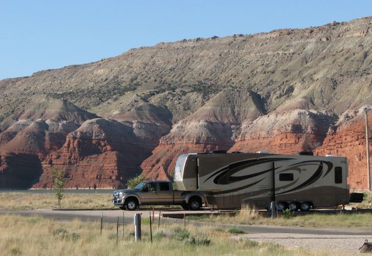
Horseshoe Bend Campground
Pepé and Penelope sitting above the marina.
Wyoming clouds in Pepé's window
Wyoming landscape in Penelope's dining room windows.
There were many awesome ski boats at this lake. They were outfitted with bazooka speakers and board/ski racks on the towers. This picture is for Jay & Mitzi
Ed and Steve went fishing, not much catching this time, but lots of fishing!
They started on the dock at the marina in the morning.
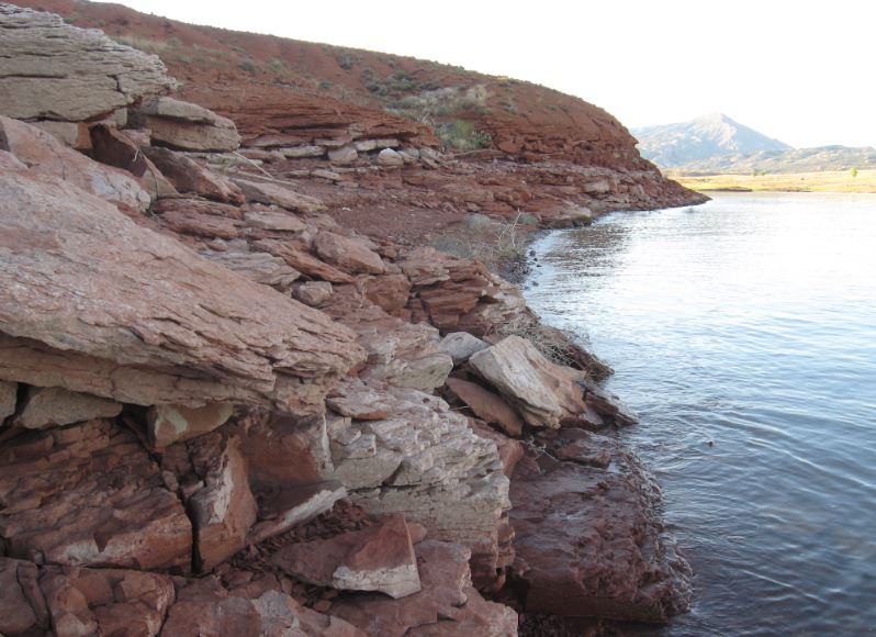
That evening Steve walked around the lake and saw a snake. Looking back across the lake toward the marina and campground. There was a jumper, which was not necessarily a feeder; see the splash ring in the lake to the right.
Looking back across the snake rock shoreline Stupid Steve walked over. Lots of snake hiding places.
One day before the rest of the group arrived, Gari & Steve walked the trail at the campground up to the Canyon Overlook. Looking back over the campground.
Steve going too close to the canyon cliff for a picture.
That's the not worth it picture!
One day Gari, Cheryl, Lynn and Steve rode up into the Bighorn Mountains to visit the Medicine Wheel and possibly see a nice waterfall. First stop was this scenic overlook 3/4 of the way up the mountain.
Zoom in.
Steve waving at the scenic overlook.
Second stop the Bighorn Medicine Wheel. The Medicine Wheel is an 80-foot-diameter circle of stones located in the Bighorn National Forest on the western peak of Medicine Mountain, in north central Wyoming. Twenty-eight radial rows of rocks extend from a center point to the outer rim of the wheel. Many stone circles can be found throughout the western United States and Canada, but the Bighorn Medicine Wheel is possibly the best preserved of all such sites. For many traditional Indian people, the Medicine Wheel is considered to be the altar for Medicine Mountain, a site of great spiritual significance.
Kasey greeting us at the trail head to Medicine Wheel, and giving us the bit of Medicine Wheel history that is known.
Walking the 1.5 miles up to the Medicine Wheel; Cheryl, Lynn and Steve below. Photo courtesy Gari.
Stopping for a group photo, Gari, Cheryl and Lynn. Photo by Steve.
Gari half way to the Wheel.
For my NASA friends; there was an FAA aircraft surveillance RADAR on the eastern peak of Medicine Mountain. I understand this site provides surveillance for multiple states.
At the Medicine Wheel.
"Eventually one gets to the Medicine Wheel to fulfill one's life." ~Old Mouse, Arikara
Prayer offering flags line the rope perimeter. Near the center hub is a Buffalo skull and feather offering.
Zoom in on the Buffalo skull
Cheryl, Gari and Lynn, L to R at the Wheel.
Looking to the west.
Indian Paintbrush near the Wheel.
Now we are on our way to Porcupine Falls. On the way Steve and Gari saw their first wild Moose! Cheryl spotted it, Lynn photographed it, Steve looked through the binoculars at it. The picture below is not the same moose, but it looked very similar through the binoculars. I carefully selected this picture from the Internet as a similar looking representative Moose. We didn't want to be like Yahoo and talk about something and not include a picture!
Steve, Lynn and Cheryl idling in the shade at the Porcupine Falls Trail Head.
The trail out to the falls was all down hill, very steep down hill, which means the walk back will be all the more difficult. It was so steep that there were stairs in several sections of the trail!
We see the falls!
Moving closer for a better look.
Lynn, Cheryl and Steve at Porcupine Falls in Wyoming's Bighorn Mountains.
Gari making the falls much more beautiful.
We had a Full Moon Party once we returned to the Horseshoe Bend campground. Ed and Lynn fed the entire army with their signature camping quesadillas. What a fantastic end to an incredible day!
One day we had a big storm blow through with 50 mph straight line winds. You can see the clouds shearing off and pouring over the mountains as the wind headed straight for the campground. We were all glad when that storm was over.
We took a ride north into the Bighorn Canyon until the road ended one day, below are the highlights of what we saw. Riding up over the hills and into the canyon.
Gari at the Sullivan's Knob overlook.
Looking south at Sullivan's Knob.
A small group of wild goats. They seem to be shielding the baby.
Baaaaaa
Bighorn Canyon.
Pepé parked at Devil's Canyon overlook.
Devil's Canyon.
Gari at Devil's Canyon.
Devil's Canyon.
The last stop at the end of the road, Barry's Landing.
We love Wyoming!
The
Medicine Wheel is an 80-foot-diameter circle of stones located in the
Bighorn National Forest on the western peak of Medicine Mountain, in
north central Wyoming. Twenty-eight radial rows of rocks extend from a
center point to the outer rim of the wheel. Many stone circles can be
found throughout the western United States and Canada, but the Bighorn
Medicine Wheel is possibly the best preserved of all such sites. For
many traditional Indian people, the Medicine Wheel is considered to be
the altar for Medicine Mountain, a site of great spiritual significance.
- See more at:
http://www.sacredland.org/medicine-wheel/#sthash.XByPY57v.dpuf