We worked in a favorite hike this month, The Crack, in Sara Park at Lake Havasu just a few miles up the road from our Parker, AZ home. We discovered this hike last year on our way north for the summer. Last year we stopped at the end of the slot canyon (The Crack) and turned back to the truck and trail head. This year we decided that we would walk the extra 2.5 miles and walk all the way down to the lake (Lake Havasu). The total hike loop was 5.2 miles with an elevation change of ups and downs adding to about 850 ft. Not a super difficult hike for us, but a good one. We were plenty tired upon our return to the truck.
There we are below, just past the trail head and excited by the already rugged mountains behind.
We came to a fork in the path so we were forced to take it....
Gari has a good sense of direction and a handheld GPS! She carries the GPS in one of the zipper compartments in her fly fishing vest turned explorer vest. She has more goodies in that vest than Batman has in his utility belt!
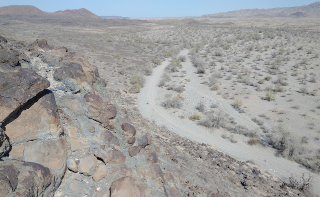
We know that we will find the slot canyon if we follow the big wash or dry river seen below.
So off Gari goes down the wash, headed in the direction of the lake. And by the way, the middle peak in the frame below is Lizard Peak, which we will say more about shortly.
You can see the trails on either side of the wash. We walked on these trails as much as possible, because they are much more firm. The wash is very sandy with marbley pebbles, which makes the walking much more difficult. At some point we will have to get into the wash, which becomes the slot canyon, The Crack.
Similar view below, and now you can see a strangely round rock where most other rocks are sharp and jagged.
We noticed the round rock as we passed it from the opposite side of the wash. The canyon walls are starting to grow taller...
The canyon walls are getting much taller now, and we are in the wash approaching the slot canyon part of the hike.
This looks like the beginning of the slot with the interesting rock erosion patterns and meandering wash bed.
Steve gets a hero shot.
An interesting rock up high at the entrance to the slot. That looks more like the lizard to us!
Zoomed in on the lizard looking rock...
The slot is starting to drop fast. We suppose that's what accelerates the dramatic erosion here.
We came to the rope installed by the local Havasu hiking club. Steve repels down the ~9 ft wall.
Gari comes to the rope scramble next...
Gari elects the safer slide decent. Smart woman.
Below Gari negotiates a particularly narrow and steep section of The Crack with a Class 3 scramble. Class One is just walking along. Class Two is when you have to touch the ground or walls with your hands. Class Three is when you have to bear weight with your arms and hands.
We came to a boulder obstruction in the Crack. The hiking club fitted two small sections of aluminum ladder to assist hikers passing this pinch point. Steve climbs over.
Here comes Gari clearing the boulder.
The last 100 ft or so of the Crack are very narrow and lean to the right as you walk through. We felt the claustrophobia a little bit more this time through. The first trip we didn't notice it as much because we were distracted by the beauty and wonder and not thinking of the danger and risks.
Near the end of the slot there was a nice photo opp for cool erosion pattern photos.
Gari exits The Crack victorious!
Looking ahead it appears that the lake must be before the mountains in the distance. The rock cairn points the way.
Oh yes, our first peek-a-boo view of the lake!
We made it! Gari gets a hero shot.
We had to touch the water after coming all this way. It's a must!
There was an interesting multiple Hoodoo type rock formation where we reached the lake...
Up on top of the rock formation sat a Great Blue Heron for the longest time. Yep they are all the way out west here! He eventually flew away.
There was a group of Mallards that swam over to inform us it was snack time. We all enjoyed a few mini pretzels together,
The water was nice and clear.
As we headed back on the loop trail we looked back and had a good view of Balance Rock, a hiking destination in itself. Named for fairly obvious reasons.

Close up on Balance Rock showing the layers and textures.
A little farther along the loop back trail, we turned for a last panorama of the lake.
We came upon an interesting rock ledge.
Of course Steve had to walk out and investigate more closely. You may be able to see the fascinating wind erosion lines on this rock. Look below Steve's feet closer to the camera. Those small ridges were sharp as a knife's blade! In fact the entire area of rocks looks wind blown to the left!
We could see a small craggy window arch from the vantage point of the rock ledge.
We passed right by the curious round rock on our way back on the loop back trail. Gari got a Round Rock Hero Shot!
And finally the comment about Lizard Peak and Picnic Table Trail. That is both below. We agreed that our next hike out here at Sara Park will be this one. We hear there is a fantastic view from up there.... and a picnic table too!