This day was a particularly ambitious day. We rose early and headed out for Taylor Park Reservoir and the Taylor River with our fly fishing and other fishing tackle. The reservoir is just north of Almont, Colorado where a nice size fish hatchery operates. After enjoying a morning of fishing and picnicking along the Taylor River, we still had a lot of daylight left and decided a nice scenic ride up to Lake City may be entertaining. Lake City is a little bitty mountain town very far away from any other civilization. It is nestled between Lake San Cristobal and the San Juan Mountains.
It was a cool and unsettled morning when we arrived at the Taylor Park Reservoir. A small inversion still hung in the air in front of the mountains across the lake.
LtoR: Steve, Michelle and Jim line up on the bank and begin to test the waters with their flies and lures.
Gari and Michelle prepare to reel in the Trout.
Jim takes a seat up here at 10,500 feet, and Steve moves down to a rocky point.
Steve casts his flies out. The fly rigs they use up here have multiple flies. The first is a dry fly of some sort, often called the Indicator. These are usually big enough so you can see them after you have cast out. It lets you know if you are getting a bite. The next one or two flies are usually wet fly's or nymphs. Steve is using a two fly set up here.
Fish on! It's a nice Brown Trout.
Michelle winds up for a mighty cast out.
Michelle and Jim have their lines in the water and are ready for some live action!
Steve moved to another rocky point and casts his flies out again
After a bit we moved on downstream to try our luck on the magnificent Taylor River trout stream.
We loved the scenery up here around 10,000 feet.
Jim finds a nice back eddy and casts in his flies.
Steve works the flies behind a giant rock.
Jim believes that the rare wilderness power nap is a highly underrated activity.
Moving on down the river, Steve finds a spot where he can hop across the rocks to reach an inviting looking pool above the small rapids.
Jim works a spot in the cool shade of a Cottonwood tree.
Time for a food break, so we set up a little picnic stream side.
Then off we went, headed for Lake City. This little ride turned out to be a number of scenic stops along the way, more so than a destination journey to Lake City. This first stop was a mesa formed from majestic pinnacles.
We liked it, so we took a group selfie.
At a later stop we met the couple from Texas that were parked across the road from us back at the campground. It turned out that Jim and the man knew some of the same folks from our previous working life. You can see Jim and the man talking behind Michelle and Gari. Small world.
By the way, it was pretty scenery at that stop too.
We arrived at Lake City and went into the Visitor's Center. There we met the Sheriff and some of the folks that worked for him at the center. We captured the sign over the door, and this is a very good summary. Lake City is smack dab in the middle of some of the wildest mountain country period.
From the next stop we could just get a peek of Lake San Cristobal below.
This shot is from the overlook directly above the lake. Sure is beautiful down there.
We wouldn't have known it if the marker had not told us. It turns out that this is a rare example of an earthflow, called mass wasting; later named the Slumgullion Slide. About 700 years ago, an area of Mesa Seco, slid down the mountain and blocked the Lake Fork of the Gunnison River. This natural dam formed what is now known as Lake San Cristobal. The earthflow is about 4 miles long and covers over 1000 acres. You may wonder where the name "Slumgullion" comes from, as did we. The Slumgullion Slide was likely named by early settlers of Lake City who noted that the yellowy color of the soils resembled Slumgullion Stew. "Slum" as it was also called, was generally a watery stew made from beef, potatoes, carrots, and onions, or whatever leftovers could be found. Also, miners of the 1800s referred to the leftover mud in gold sluices as slumgullion.
Below is the marker that tipped us off with the story.
An interesting stand of trees, that's all.
We see the San Juan Mountains from this stop at 11,000 feet, nearly 2,000 ft above Lake City.
A wider angle view exposes the lush valleys. The San Juan mountains are volcanic in origin formed around 30 million years ago. Rich deposits of gold, silver, zinc and lead attracted prospectors in the 1870s, which contributed significantly to the development of this area.
This tall skinny tree begged for it's own shot in the blog.
Hellooooo doooooown thereeeeee! We stopped at the summit for a high altitude selfie. Hypoxia causes excessive smiling.... just saying.
The farthest reach of our ride this day was to the Continental Divide at just under 11,000 feet.
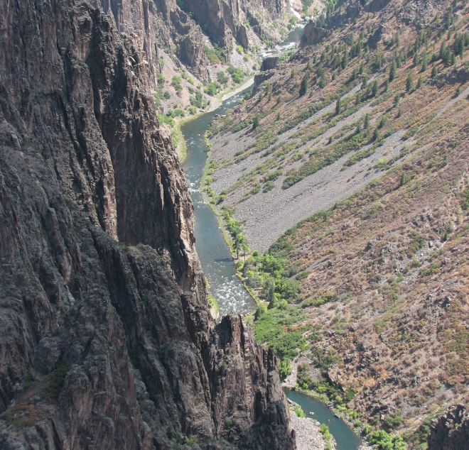
On the way back to the RV park we stopped at an over look along the Lake Fork of the Gunnison River. There was a little wind at this stop. Michelle and Gari capture some pictures of what we thought was an interesting situation.
There we could see the Lake Fork River below.
Below is the oddity we noticed... Did these folks build their mountain home directly over some sort of mine or cave?!?
A little closer view shows that the hole is very large indeed. Maybe this place belongs to Bruce Wayne and there is a Batpole leading from the library down into the Batcave... but that is doubtful.
For now we say so long to Lake City, Colorado