Friday, September 29, 2017

Fishing the Kootenai River and Koocanusa Lake

We fished several spots along 15 miles or so of the Kootenai River.  We also put our kayaks into the big lake Koocanusa.  As it appears, the lake was named after the River itself, The Kootenai, Canada where the water originates and the USA where the water flows - KooCanUSA.  Libby sure is pleasant... in the summertime!  We don't believe we would thoroughly enjoy the winters!

The Libby Dam from our kayaks above the dam on Lake Koocanusa.  This was as close as we were permitted to get to the dam in our boats.
We went on the dam tour one day and learned some fascinating facts.  Unfortunately no pictures were permitted.  The Libby Dam was completed in 1972 in an effort to provide flood protection and to generate hydroelectric power. The Kootenai River fluctuated wildly in the spring causing flooding in Montana, Idaho and British Columbia, costing millions of dollars in flood damage.  Libby Dam is architecturally one of the strongest and most massive types of dam built today. The dam is 422 feet tall and 3,055 feet long and was built to withstand an earthquake of up to 6.5 on the Richter scale with no structural damage. Forty-seven monolithic sections make up the dam, each one designed to stand on its own like individual dams. The architect on this COE project decided that there would be minimal right angles in the construction, and this can be seen throughout the project.

There is Gari below the dam on the Visitor Center side.  In addition to Gari's beauty, you can see the slope of the dam at 17 degrees blends in with the surrounding hills.
Below is a view on the opposite side of the river, from the viewing platform below the dam.  You can see the slope on the back side better in this view.
View from the same platform below the dam looking down river.
Steve is testing the water for wading below the dam.  We understand there are trophy trout in there and we wanted to determine if we could wade or put our kayaks in.  There was a bit too much current to try and fish from the kayaks.
This view above the dam shows the Dirty Shame Landslide.  That is the bare spot right at the end of the dam.  A huge section of mountain broke loose while the road on that side was under construction.  Luckily it occurred early on a Sunday morning when no one was working and therefore no lives were lost.  The COE now monitors the entire hill with sensors looking for any movement.
Gari works her lure on the Kootenai River some 5 miles below the dam.
Gari has a small Rainbow Trout west of Libby on the Kootenai.
Steve on the banks of the Kootenai River somewhere below the dam.
Steve works some rapids on the Kootenai.
Steve wades in to get a few more feet onto his cast.
A good fishing spot 5 miles or so below the Libby Dam.
Steve gets a picture of a nice Rainbow Trout.
Steve has a Rainbow on, and it's jumping!
Reeling it in.
Nice little Rainbow!
At a pool on the Kootenai River.
 Looks like a Cutthroat Trout in the water.
Steve likes this nice Rainbow Trout!
 Trout on a Money Clip spoon.
 Gari reeling in a Trout on the Kootenai River.
A little fly rod action on the Kootenai River.
Steve lays down the fly cast.
Nice follow through... now catch a fish!


Friday, September 22, 2017

Hiking and Paddling in Libby, Montana

As mentioned in our previous post, we enjoyed the fishing around Libby.  Below is a shot of Steve and Gari fishing along the Kootenai River just north of town.  This is a very interesting river.  The COE folks at the Libby Dam manage the flow through Libby and below and that determines the conditions for farming, fishing and other recreation.  They also want this river to produce trophy trout and therefore limit the open season, and when it is open the limit is two fish that must be 29" or longer!  As a result there are an abundance of fish in this river.  Yeehaa!

A few pictures below from a paddle and fishing expedition on Bull Lake near Libby, Montana.  Kayaks ready to put out.  A calm morning on Bull Lake but some smoke hangs in the air...

 Steve is out on the water ready to wet a line.
 Steve closes in on the western shore.
Steve has a strike!
 Impressive... but not in the good way.
 Looking off Gari's bow on this still morning.
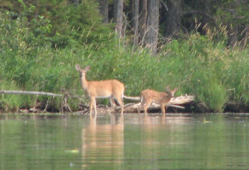
Gari spots a Doe and her fawn by the waters edge.
 The fawn is very curious.
 Steve unhooks another whopper.
Gari got out of her kayak to scout the bushes and immediately sees... bear scat!
 Bull Lake looking south.
 Gari has a fighter!
Gari glides along silently...
The Ross Creek Cedars were nearby Bull Lake so we slipped by that old growth of giants for a short hike that same day.  Gari holds her Garmin GPS up to lock the satellites so we can get this hike underway!
We found trail 142 and walked for a few miles down that before turning around.
Gari leads the way into what looked like a prehistoric forest.
Come with me, walk with me into this hushed place.
A cooling air greets us, a dimming light softening through silent shades of ancient green.
Gari stands at the roots of a long since fallen giant.

Gari in front of another giant down.
 A root tangle.
 More perspective on that tangle.
 Steve stands between giant twins.
Small Steve, Big Cedar.
 Trail 142, Steve moves out.
Gari among more giant friends.
Stand still!  Hush!
You will hear that quiet thrumming, which is the heart of the Earth,
tapping deep into some richer well of the soul's eternal seeking.
Hold onto that peace; it calls to you from a deeper place.
Drink in the stillness of this hallowed grove, and be content.
The leaves of the undergrowth are also giant. Steve's thumb to pinky is 10" across.
Those leaves have small red berries.
 More berries among the ferns.
 Steve leans on a giant friend.
 Gari climbs between two giant friends.
Gari crosses the dry wash.
 Shelf fungus.
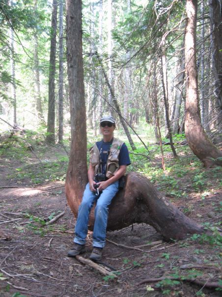
Gari finds a seat on an Indian trail marker tree.
 Perfectly whorled fern surrounded by the big leaves.
Gari stands in a fire scar on this Cedar.
Steve found a stick up with Pileated Woodpecker holes.
Next post - fishing the Kootenai River and Lake Kooncanusa...