We forgot that we had one more hiking and touring expedition while we were staying in the Cody, Wyoming area. We had heard that there was still 8-10 ft of snow up on Bear Tooth Highway in late June, so we had to go up and see that for ourselves! We actually took two trips; the first was a truck tour on a 210 mile loop on Chief Joseph Scenic Highway and Bear Tooth Highway, the second trip was a hike off Chief Joseph Scenic Highway on Dead Indian Trail. There is an awesome story in our country's history about how Dead Indian Pass got its name.
Chief Joseph Scenic Highway is seen winding through the hills below.

The Dead Indian Pass is portal between the mountains and the plains where great game herds migrated seasonally. Many Indian hunting and war parties, and miners seeking their fortunes in Cooke City crossed this pass. In 1877 Chief Joseph led his Nez Perce Indians in a strategic and defensive retreat as they were pursued by what was left of the Seventh Calvary of the U.S. Army. The Seventh Calvary had almost been wiped out a year earlier with General Custer at the Battle of Little Big Horn. The Nez Perce knew the Army did not intend to leave a single survivor in vindication and this became a fight for their lives. The Nez Perce were 600 strong with 2,000 horses. They had been on the run for more than 60 days and were exhausted, sick and wounded. The Army had encircled the Yellowstone area with more than 20 Companies leaving no escape route for the Nez Perce. The Nez Perce knew the Army was a little more than a day behind them. Led by Chief Joseph and Lean Elk the Nez Perce milled their horses in all directions near Dead Indian Pass to leave a confusion of tracks. Accounts tell us that the Nez Perce left a wounded warrior on this
hill. He was discovered and killed by Army Scouts, and this area then
became known as Dead Indian Pass. Then they back tracked down a rough canyon to the Clarks Fork of the Yellowstone River. The misdirection worked, it confused the Army scouts long enough for the Nez Perce Indians to accomplish the unbelievable and successfully escape!
At the trail head of Dead Indian Trail there was a corral with someone's nice Bay in there.
The Bay noticed us as we passed by.
Beware the Bear!
Steve starts down the trail.
Sap on the pine cone.
Majestic hills.
That's Gari out front now.
We walked above Dead Indian Creek. This is a spot where a fairly deep miniature canyon was carved out over the ages. The run off from the melting snow has been substantial this year and you will see more evidence of that in later pictures.
Gari pauses to take in the beauty around us.
Gari finds our picnic spot with a nice big rock to sit on.
For dining entertainment, we had our own little waterfall of runoff plunging into the rushing waters of the creek below.
Be careful, you don't want to fall in here!
We finished our trail snack and departed the canyon area.
Gari looks back over our trail as she contemplates being lost somewhere in America.
Steve never realized he was lost.
Next stop a little picnic area that appeared to have some flooding and pretty stunning runoff waterfalls; thought we had better check that out. We had the place to ourselves.
The picnic area was right on the rushing waters of Dead Indian Creek.
Gari examines a small runoff stream flowing right through the picnic area.
We had to cross to see the source of the water. Gari lines up the jump...
and Geronimo!
The runoff cascades down through the forest.
The water floods most of the meadow. Tiny waterfalls expose every drop off.
Steve goes ahead down into the creek bottom in search of the spectacular runoff falls.
Looks like there are predators down here. What ever that was, all that's left is the whiskers!
A major cascade coming out of the forest.
The entire area appears flooded and the water just falls into the swollen creek.
Waterfalls everywhere!
Last look and ready to head up out of the bush.
Back on top, no bears up here. Another fine hike completed. Now on to see all that June snow on Bear Tooth Highway we have heard about.
As we started up Bear Tooth Highway toward Red Lodge, MT we saw a few pristine mountain lakes and the snow melt rushing runoff that feeds them.
Bear Tooth Mountains.
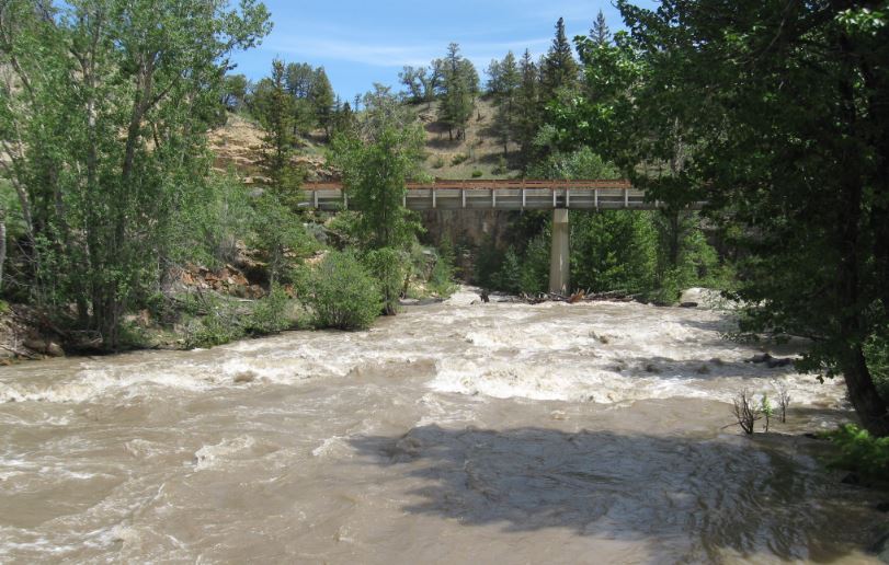
Swollen Lake Creek which flows into Clarks Fork of the Yellowstone River.
Another swollen creek rushing toward the already swollen Clarks Fork.
Gari smiling by the rush of Lake Creek.
Bear Tooth Mountains from Lake Creek area. There is some snow up here, but we want to see how much.
Getting higher now and crossing a barely thawed stream in the otherwise frozen landscape.
Well there it is! I would agree that is about 8-10 ft of snow. Who would have thought at the end of June?!
Another surprise, an operating ski lift at the end of June!
Last pass going into Red Lodge, MT.
This was our picnic spot on the truck tour day. Lots of snow up here.
Steve makes a snowball in June while eating his granola bar.
Just then a snowmobiler climbs the hill in the distance, see him?
Below is a more clear shot.
Yep, there's snow up on Bear Tooth in late June...
Lots of snow.
And Gari takes us out of this epic excursion until the next one...


No comments:
Post a Comment